

Ipsa Tripathy
Bhubaneswar: Last week, Odisha watched two cyclones form over the Bay of Bengal within days of each other. Arnab crossed the Andhra Pradesh coast on October 28, and Murasu followed less than a week later. The back-to-back storms raised a familiar question: why does India’s eastern coast seem to face cyclones so frequently, while places such as Mumbai and Kochi experience them less often?
The answer lies partly in the temperature of the sea, the movement of air above it and the enormous volume of freshwater flowing into the Bay. Geography and weather patterns also play an important role. Together, these factors make the Bay of Bengal more favourable for cyclone formation than the Arabian Sea.
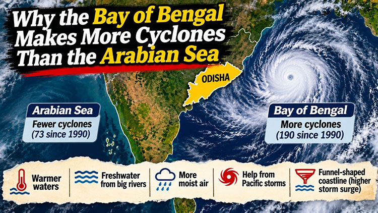
The difference in cyclone activity is considerable. According to the India Meteorological Department’s regional cyclone centre, roughly four cyclones develop over the Bay of Bengal for every one that forms over the Arabian Sea. Between 1990 and 2020, the Arabian Sea recorded 73 tropical cyclones, compared with 190 over the Bay of Bengal.
The consequences are particularly serious because of the densely populated coastlines surrounding the northern Bay. Cyclones over the Bay of Bengal and Arabian Sea together account for a relatively small share of global tropical cyclones, but have historically caused a disproportionate number of deaths. Some of the most devastating storms in the region’s history, including the 1970 Bhola cyclone and the 1999 Odisha super cyclone, originated in the Bay of Bengal.
One of the main reasons for this difference is sea surface temperature. Tropical cyclones generally need warm ocean water, usually around 27°C or higher, to develop and strengthen. The Bay of Bengal frequently maintains temperatures above 28°C, providing a steady source of heat and moisture for developing weather systems.
The Arabian Sea also experiences warm conditions, but its surface waters are influenced by stronger winds and patterns of ocean circulation. These can increase evaporation and bring cooler water towards the surface, reducing the heat available to developing storms in certain seasons. The Bay, by comparison, often retains warmer surface waters for longer periods. This gives developing low-pressure systems a more favourable environment.
Another important factor is the large volume of freshwater entering the Bay of Bengal. The Ganga and Brahmaputra rivers discharge enormous quantities of freshwater into the northern Bay, while the Mahanadi, Godavari and Krishna also contribute to the region’s freshwater supply. Rainfall adds further freshwater to the surface.
Freshwater is less dense than seawater. When large quantities accumulate at the surface, they can form a relatively stable layer above the saltier water below. This reduces vertical mixing and can prevent cooler subsurface water from rising easily to the surface. As a result, the warm surface layer can retain more of its heat.
This matters because a developing cyclone draws energy from warm ocean water. If cooler water is mixed upwards, it can lower the sea surface temperature and weaken the system’s energy supply. A stable freshwater layer can help limit that cooling, allowing warm conditions to persist even when strong winds begin stirring the ocean.
The Arabian Sea receives less freshwater from major rivers, and its ocean conditions are influenced by stronger mixing in several areas. This can bring cooler water towards the surface and affect the conditions available for cyclone development.
Moisture in the atmosphere is another important part of the explanation. Cyclones need warm, moist air to sustain the thunderstorms that surround their centres. The Bay of Bengal generally has high atmospheric humidity, providing a favourable environment for the growth of these systems.
The Arabian Sea, meanwhile, can be influenced by relatively dry air from the Arabian Peninsula and surrounding regions. Dry air entering a developing storm can interfere with thunderstorm activity and weaken its circulation. The amount of moisture available in the atmosphere therefore helps determine whether a weather system can strengthen or struggles to develop.
Weather systems arriving from the Pacific may also contribute to cyclone activity in the Bay of Bengal. Some tropical disturbances that develop over the western Pacific move westwards towards Southeast Asia. Their remnants can enter the Bay of Bengal as low-pressure systems or depressions. If they encounter warm water, sufficient moisture and favourable atmospheric conditions, they may strengthen further.
These disturbances do not automatically become cyclones. Their development depends on several factors, including wind patterns, ocean temperatures and the organisation of the surrounding atmosphere. Nevertheless, the movement of weather systems across the wider tropical region provides another pathway for disturbances to reach the Bay.
The shape of the Bay also influences the damage caused by cyclones, particularly in its northern reaches. The coastline curves around a broad, shallow region that includes the deltas of several major rivers. When a strong cyclone approaches, its winds can push seawater towards the coast, producing a storm surge. The shallow coastal waters and the shape of the shoreline can contribute to higher water levels in some locations.
This is one reason why Odisha, West Bengal and Bangladesh face serious storm surge risks. Low-lying coastal settlements and densely populated delta regions are especially vulnerable to seawater entering homes, agricultural land and freshwater sources. The actual height and reach of a storm surge depend on the cyclone’s intensity, size, direction of approach, tides and local coastal geography.
The timing of Arnab and Murasu also fits the Bay’s usual cyclone seasons. The region generally experiences two periods of heightened cyclone activity: before the southwest monsoon, during April and May, and after the monsoon, from October to December. October and November are particularly important months for cyclone formation.
Historical observations show that a substantial share of cyclones making landfall along India’s east coast occur during October and November. The back-to-back arrival of Arnab and Murasu was unusual in its timing and impact, but it took place during a period when the Bay of Bengal is naturally more favourable for cyclone development.
There is, however, an important change taking place in the Arabian Sea. For many years, it was considered less favourable for cyclone formation than the Bay. That distinction is becoming less pronounced.
A study by scientists at the Indian Institute of Tropical Meteorology in Pune compared cyclone activity during two periods, 1982–2000 and 2001–2019. It found that the number of cyclonic storms in the Arabian Sea increased by 52 per cent in the later period, while the Bay of Bengal recorded an 8 per cent decrease. The number of very severe cyclones in the Arabian Sea rose by 150 per cent, and the total energy associated with its cyclones nearly tripled.
Rising ocean temperatures are an important part of this change. Climate scientist Roxy Mathew Koll has noted that parts of the Arabian Sea have warmed by around 1.2 to 1.4°C over the past two decades, substantially faster than the global average warming of approximately 0.8 to 0.9°C over the period discussed. Warmer water can provide more energy for developing storms, while changes in atmospheric moisture and circulation can also influence their behaviour.
This does not mean the Arabian Sea will immediately overtake the Bay of Bengal in cyclone activity. The Bay still produces more cyclones overall. But the growing activity in the Arabian Sea shows that historical patterns are not fixed. As the oceans warm, regions that were once considered less favourable for intense storms can become more active.
For Odisha, the reasons behind the Bay’s cyclone activity are more than an interesting scientific question. The state’s location along the eastern coast places it in the path of storms that develop over the Bay, particularly during the post-monsoon season. Early warnings, cyclone shelters and large-scale evacuations have helped Odisha reduce deaths during major storms. The experience of recent cyclones, however, shows that preparedness cannot end when the winds begin to weaken.
Heavy rainfall can continue well after landfall, triggering floods and landslides in the southern hills. Agricultural losses, damaged roads, coastal erosion and disruptions to livelihoods can persist long after the cyclone has moved away. These effects require the same attention as wind speeds and storm surge forecasts.
The Bay of Bengal’s geography and climate will continue to make it an important region for cyclone formation. Its warm waters, freshwater inflows, atmospheric moisture and seasonal weather patterns create conditions in which storms can develop. Odisha cannot change these natural factors, but it can continue improving how it prepares for their consequences.
Cyclones may be a recurring feature of life along the eastern coast. The scale of the damage they cause does not have to remain the same.
